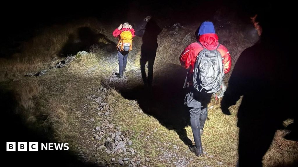
More young people are getting caught out on the fells due to relying on Google Maps for navigation, rescuers have said.
After a full-team rescue on Sunday, Wasdale Mountain Rescue Team (WMRT) said an increasing amount of young people, mostly aged 18 to 24, were getting lost or into trouble after using Google Maps on their phones.
WMRT said Google Maps was "not made for the mountains", because unlike a paper map, the app does not display steep rocky outcrops, fell paths and contours, which show three-dimensional shape of the land.
The advice to use a paper map – which is echoed by Google – has been repeated by rescue teams for years, so how can navigation be made more available to young people?
"It's a tricky one," mountaineering and climbing instructor (MCI) Pippa Archer, who lives in Kendal, said.
"I can see the appeal of using something that is free and readily available on your phone, however, a map and compass won't set you back too much," she said.
Archer, who guides and helps people develop their skills in the mountains, said the detail on a paper map was "crucial for staying safe" and "gives a picture of what to expect on your walk, and this is the key to not getting lost".
"A walking map will show you where the ground gets really steep, where there are cliffs to avoid, or streams that need to be crossed," she said.
"The apparent increase in Google Maps use in mountain environments may reflect changing navigation habits rather than simply poor preparation or judgement," winter mountain leader and MCI James Anstee said.
Anstee, who lives in Windermere, said the app's "familiarity and reliability in everyday settings may create an assumption that it is equally suitable for the mountains", without full appreciation of what the terrain demands.
"The challenge is therefore as much about awareness and education as it is about technology," he said.
He said encouraging people to understand limitations of navigation applications, learning about terrain and appropriate navigational competence was "likely to be more beneficial than simply discouraging the use of a particular app".
As a secondary choice for navigation on the phone, WMRT recommended OS Maps, Hiiker or Outdooractive apps which were made for walkers.
Even with the rise of digital devices in recent years, Archer said a compass and a map were still the safest tools, as apps can freeze without signal or could need an update while up on the fell with no phone signal.
It comes as three men needed help on Sunday after they got lost walking from Scafell Pike using Google Maps, which had not updated, rescuers said.
Archer said: "If I used my phone for all my navigation it would quickly run the battery down, compromising my safety if I did need to call for rescue.
"I only use a navigation app for two purposes: to quickly pinpoint my position, or to zoom in to see the map better," she said, and advised people to take screen shots of a map as a back up.
Archer said: "I know some people worry they don't know how to use a compass, but the main thing to remember is that the red end of the needle always points north.
"Knowing this then allows you to work out which way is east, south, west or north, and combining this knowledge with the map allows you to select the right path down from the summit."
Archer advised those getting to grips with navigation to "head out on a route that you know, but take a walking map with you, and see if you can piece together how the land around you is represented on the map".
"You'll probably need a few pointers as you bring in the compass, so head out with a more experienced friend or sign up for a one-day navigation course," she said.
A Google spokesperson said the company's map app was designed for streets and that it "calculated estimated time of arrivals based on standard walking speeds and showed clear warnings that conditions may vary".
"We encourage hikers to use trail maps and apps designed specifically for hiking," they said.
Follow BBC Cumbria on X, external, Facebook, external, Nextdoor and Instagram, external and listen to Radio Cumbria on BBC Sounds.
Do you have a story suggestion for BBC Cumbria?



Discussion